Some how it got cold again. Seriously, at about 4am today our heater turned on. I have no idea what is going on. I think I prefer the oppressive heat of the Southwest. At least then I know what to expect.
senseFly Announces eBee RTK Survey-grade Mapping Drone
This is really cool. I was talking with a colleague a few months back about whether or not someone could use a UAV as a relay in areas of dense cover. I was suggesting that you could use the UAV as part of a system where position correction was involved. With the proper calculations the drone would know where it is and could help augment the multipath issues. This works similarly except that the base station provides correction to the UAV. The UAV can then collect imagery without the use of control ground points.
Sounds like the cost and weight issues are finally starting to come down enough that we will start seeing this out in the field. Looking forward to seeing one in action.
County Population Growth Between 2012 and 2013 and the Primary Source of Population Change
Cool map of the day. This story map has an awesome slider where you can switch between the two layers.
MyBuild Update: Gotta get my battery recharged this weekend. On Thursday I was able to actually fly it around a little. Still working on getting the trims right. It is taking forever because, as I mentioned before, my motors are a lot to big for the amount of weight this thing has. So around 20% throttle the thing is launching to about 7 feet and then I drop it down to 10% to keep it from flying into my house. With the battery dying too my trim adjustments are going to be pretty useless since the draw is not exactly equal for each motor.
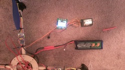
Pictured here is a detail of the wiring. Bottom right is the battery, a 3300 mAh. Going left it is connected to the breakout cable which distributes power to the four electronic speed controllers. Those are located on each arm and shown just above the hub in this photo. The electronic speed controllers then send signal and power to the motors, shown at top left. They also have signal and power to the control board shown top center. The motors actually supply all power to the control board so there are actually four cables to each, but for this detail I have only shown one. The control board then has four cables to the receiver shown top right. The antenna for that is the small read thing just to the right. Hopefully this gives an idea of what is going on electronically on this. As I mentioned, you are basically doing everything four times so you have to distribute the cables just right.
Pictured here is a detail of the wiring. Bottom right is the battery, a 3300 mAh. Going left it is connected to the breakout cable which distributes power to the four electronic speed controllers. Those are located on each arm and shown just above the hub in this photo. The electronic speed controllers then send signal and power to the motors, shown at top left. They also have signal and power to the control board shown top center. The motors actually supply all power to the control board so there are actually four cables to each, but for this detail I have only shown one. The control board then has four cables to the receiver shown top right. The antenna for that is the small read thing just to the right. Hopefully this gives an idea of what is going on electronically on this. As I mentioned, you are basically doing everything four times so you have to distribute the cables just right.
 RSS Feed
