First things first. I went to a colloquium at the University of Arizona that the Department of Geography puts on through out each academic year. Talbot Brooks provided an excellent discussion of GIS in emergency response. I was able to talk to him for a bit after the presentation and he was really nice and cordial to me (i.e. a person who has no real business talking to him).
So in honor of his presentation that included old school techniques and new school techniques merging together to get the job done and save lives, I have two things to share with you today. We will start with the new school because the old school will take up a lot of room.
Experts Team Up on Tsunami Resilience in California
I have already talked at length about how GIS can affect emergency relief. I have also talked about how pre-planning with GIS can increase to overall safety of citizens. Follow some of the links that are in this article because they lead to some interesting sites. I think that it is disheartening to hear politicians and talking heads on the news talk about emergency preparedness not worth being the tax payer dollar, but I think that the small investment in larger emergency response plans. The chances of larger emergencies are not that great, but they can devastate entire regions.
The second thing I wanted to show you came through my email without a source. I don't know who assembled it and cannot give proper citation. If you set everything up or know who did please tell me because it is interesting and I would really like to give that person all of the credit for their good work.
It is definitely worth checking out. It has larger images so just click on the "Read More" and check it out.
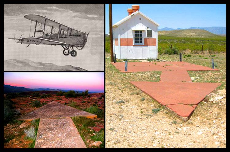
Giant Concrete Arrows That Point Your Way Across America...
Every so often, usually in the vast deserts of the American Southwest,
a hiker or a backpacker will run across something puzzling:
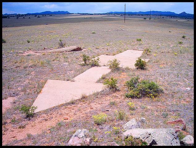
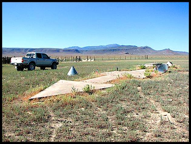
a large concrete arrow, as much as seventy feet in length,
sitting in the middle of scrub-covered nowhere.
What are these giant arrows? Some kind of surveying mark?
Landing beacons for flying saucers? Earth’s turn signals?
a hiker or a backpacker will run across something puzzling:
a large concrete arrow, as much as seventy feet in length,
sitting in the middle of scrub-covered nowhere.
What are these giant arrows? Some kind of surveying mark?
Landing beacons for flying saucers? Earth’s turn signals?
No, it's...
The Transcontinental Air Mail Route.
The Transcontinental Air Mail Route.
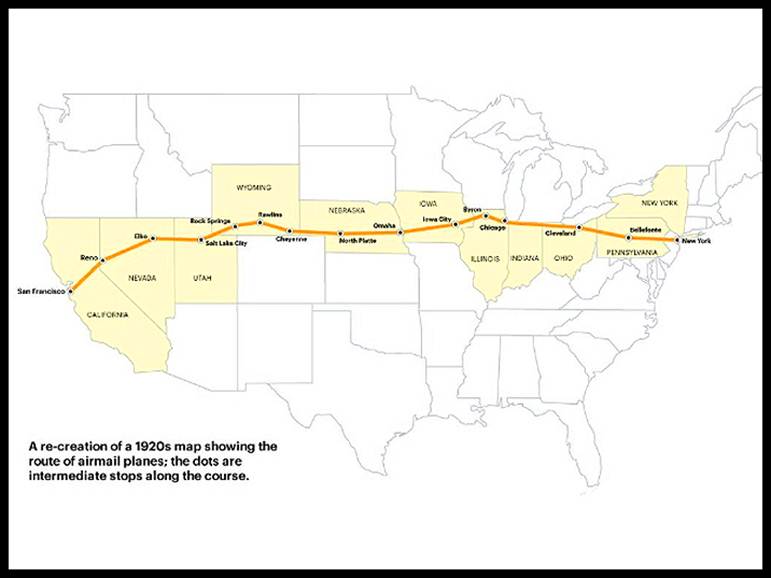
On August 20, 1920, the United States opened its first coast-to-coast
airmail delivery route, just 60 years after the Pony Express closed up shop.
There were no good aviation charts in those days,
so pilots had to eyeball their way across the country using landmarks.
This meant that flying in bad weather was difficult,
and night flying was just about impossible.
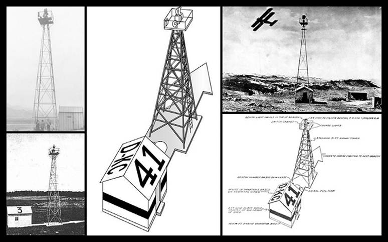
The Postal Service solved the problem with the world’s first ground-based
civilian navigation system: a series of lit beacons that would extend from
New York to San Francisco. Every ten miles, pilots would pass a bright yellow
concrete arrow. Each arrow would be surmounted by a 51-foot steel tower
and lit by a million-candlepower rotating beacon.
(A generator shed at the tail of each arrow powered the beacon.)
airmail delivery route, just 60 years after the Pony Express closed up shop.
There were no good aviation charts in those days,
so pilots had to eyeball their way across the country using landmarks.
This meant that flying in bad weather was difficult,
and night flying was just about impossible.
The Postal Service solved the problem with the world’s first ground-based
civilian navigation system: a series of lit beacons that would extend from
New York to San Francisco. Every ten miles, pilots would pass a bright yellow
concrete arrow. Each arrow would be surmounted by a 51-foot steel tower
and lit by a million-candlepower rotating beacon.
(A generator shed at the tail of each arrow powered the beacon.)
Now mail could get from the Atlantic to the Pacific not in a matter of weeks,
but in just 30 hours or so.
Even the dumbest of air mail pilots, it seems, could follow a series of bright
yellow arrows straight out of a Tex Avery cartoon. By 1924, just a year after
Congress funded it, the line of giant concrete markers stretched from Rock Springs,
Wyoming to Cleveland, Ohio. The next summer, it reached all the way to New York,
and by 1929 it spanned the continent uninterrupted, the envy of postal systems worldwide.
Radio and radar are, of course, infinitely less cool than a concrete
Yellow Brick Road from sea to shining sea, but I think we all know how
this story ends. New advances in communication and navigation technology made
the big arrows obsolete, and the Commerce Department decommissioned the beacons
in the 1940s. The steel towers were torn down and went to the war effort.
But the hundreds of arrows remain. Their yellow paint is gone,
their concrete cracks a little more with every winter frost,
and no one crosses their path much, except for coyotes and tumbleweeds.
But they’re still out there.
 RSS Feed
